
|
The 2023 storm season is now fully underway and much earlier than usual, in fact, this has been the most active and interesting March I've personally ever experienced. From mid to late March there have been numerous convective outlooks issued for Ireland and N. Ireland with the first Convective Weather (CW) slight risk boxes of the season which has been shocking to see. With the exception of one pulse storm day the main outlooks have all been high shear events, the kind of set-up more typical of a prime Summer storm day. I went chasing on three different days, one was a bust pulse weak CAPE day hunting for funnels however two of the other chases where local hunts taking full advantage of these high shear events, so let's take a look at these two fascinating days.
The first serious outlook of the year took place on March 23rd with a moist unstable SWly flow with unseasonable mild temps peaking at 15c which at the time was the warmest day of the year. 200-300j/kg of CAPE with 40 knots deep layer shear (DLS) and -40c air aloft looked to generate scattered showers and thunderstorms with the best parameters overlapping with prime solar heating. CW had issued a slight risk for organized storms and even supercells with a tornado risk. The forecast did mention a warm nose at the mid levels however the threat was still valid if this warm air could be overcome and if solar heating could take place.
My game plan was simple, the AROME indicated sheared cells over Mid-Ulster between 14.00 and 15.00 LT between Cookstown and Omagh, then moving NE with the Sperrins and NW sector of the lough being the main target zones. I wanted to get out early and get in position so I could stay E of any cells so I could get decent visibility in case they did evolve into supercellular traits, I will admit I was excited and buzzing to be on my first real chase of the year MUCH earlier than I ever had expected. By 12.00 I was on the road, it was mild however there was a keen SWly wind, I'm guessing 12-15mph however gusts were in the 20mph range, I never like fast surface wind speeds, I've never seen a funnel in such conditions and cells would be moving too fast for chasing especially when you factor in the strong shear aloft which would be the real steering winds.
I drove W out the Omagh road just a few miles from Cookstown and set-up base in a local graveyard with a good view to the W. Showers were already forming on radar and if AROME was rite I should be intercepting sheared cells within the next two hours. I watched the skies, filmed a vlog and waited with interest, I could see the shear tilting juvenile cumulus clouds over which was a great sign however I noticed the clouds had very high bases and the towers never got very high, I suspected a cap and I was rite. The cloud tops were warm and weak for the rest of the watch period, I knew this was a bust, so I headed back home.
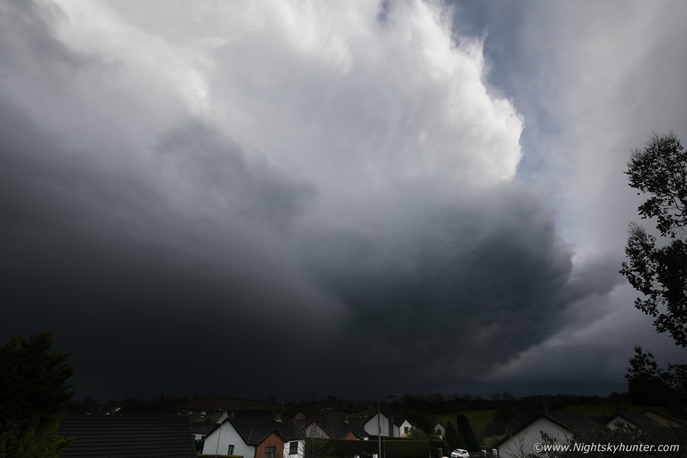 |
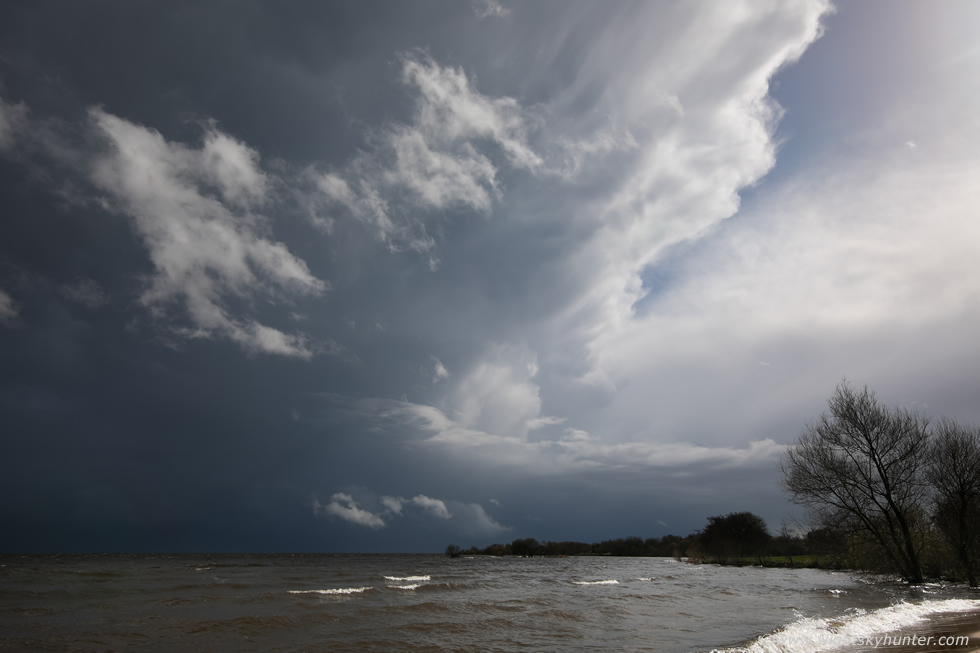
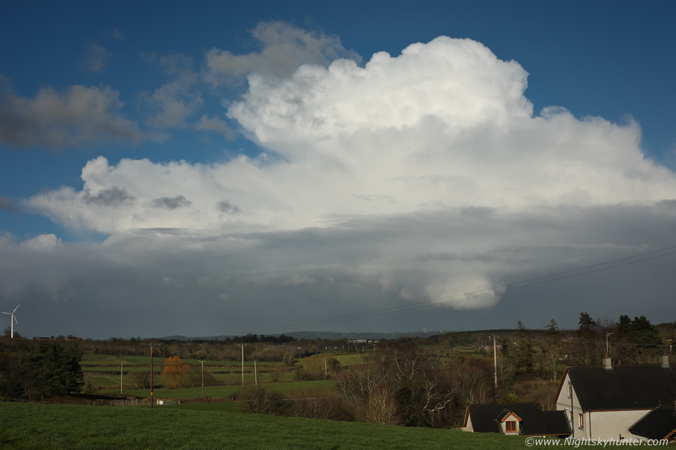
Later, I was literally shaving my head at home when an intense downpour with small hail battered the windows at 16.00, it then cleared the house and that was when I had a good look at the back edge. I grabbed the camera, threw open the skylight (no time to drive out) and shot stills through the open roof. The cell wasn't intense on radar however visually it looked great and was intensifying as it surged E. Not only was the base dark but the anvil was massive, I was shooting 15mm on full frame here and couldn't get it all in. You can see part of that white anvil sweeping upward from the back of the cell, definitely the best anvil I had seen of the season (this would get beat) so that was a nice surprise. This cell continued E and put on a spectacular mammatus display when it passed near Belfast, there were other excellent mammatus displays from Ballymena and Co. Down which were very photogenic.
 |
At 17.00 another cell passed through Cookstown and this time I got the Mavic 3 Classic in the air. This cell had a lot of girth with anvil swept back to the W against the SWly flow and mammatus too, it was simply too large to capture with the wide angle FOV on the drone, however I hovered and let it trek NE waiting for the next shot.
 |
Precip core over the Maghera area and heading for Ballymena, moving L to R and away from the camera. Once this cell passed the rest of the day was sunny and uneventful. It was obvious from radar and social media images that the E and SE of N. Ireland had the best show with mammatus displays and a few rumbles, this was due to the stronger shear moving across those areas. Even though I personally never got any dramatic photo opportunities I still enjoyed the day and was content with these cloudscapes, after all, I had to remind myself, this was only March!, and these were decent for the month, however just when I was starting to miss convection another big set-up was already on the models, it was time to chase once again.
March 29th was without question the best convective set-up of Spring, this was a classic warm season event which was technically taking place in what is officially still the cold season. Yet again a moist unstable SWly flow (Summer style) would bring a morning frontal system across the country, the front was expected to clear the middle of N. Ireland between noon and 13.00, assuming solar heating could take place then the atmosphere was expected to rapidly produce showers and thunderstorms in the post-frontal air mass. The models showed 150 SBCAPE however MLCAPE values varied from 500 to 800 j/kg which is quite remarkable for the season. CW mentioned that the temp-dew point spread was close so cloud bases would be low, this in conjunction with strong shear in the first 0-6km of the atmosphere combined with 40 knots DLS meant that the chances of tornadoes were very real and organized storms would be the order of the day. In fact, hodographs showed turning in the lower atmosphere and with winds backing later in the day supercells were possible. TORRO had issued a convective discussion for N. Ireland for tornadoes, moderate hail and splitting supercells if discrete cells could form.
I studied everything I could on the morning of March 29th, it was still raining outside, I consulted the AROME which helped me pick several target areas for chasing. It looked like sheared cells would form over the Sperrins and again over the E and SE of N. Ireland, so my targets where Mid-Ulster and Lough Neagh with Co. Armagh, Co. Down and Co. Antrim all being prime locations for late afternoon convection. My plan was to intercept the growing cells over the Sperrins then chase to the lough to view cells to my E, it was a sound enough plan. By 12.30 the front had cleared and the sun broke out, the clouds in response to this solar heating were already getting agitated, cumlulus formed rapidly and the sky already had that humid look to it which one would see during Summer, this was fantastic, I had to remind myself again that this was only March!
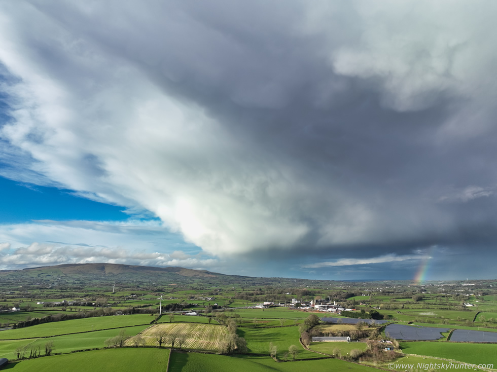
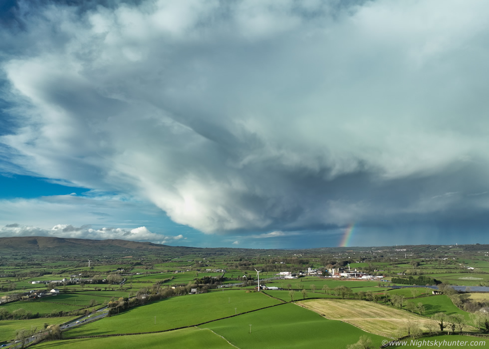
I had a message to do in Magherafelt first, by 14.00 I was free and on the road, I saw towers to my W so decided to head to Maghera then Glenshane Pass. I got on wifi for a radar check and was delighted to see that cells had already formed, two of them had elongated red cores, the first was over Armagh, the second behind it by about 30 min's of time then to the SW of those another one was forming, they looked organized and where racing NE. I wasted no time, I wanted to get my eyes on those targets so I went straight to plan B and began driving to Lough Neagh. There was no time for anything else, if I could reach the lough in time then perhaps I could observe them passing along the far side. Once I got off the main carriageway and onto the back road I could already see the first cell cluster in the distance and on the back edge was a long well defined rain free base, this was definitely organized, I even thought I saw a funnel forming however at that range it was impossible to be sure, my adrenaline soared and I drove faster.
 |
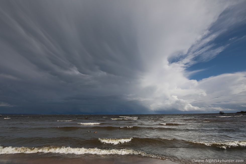
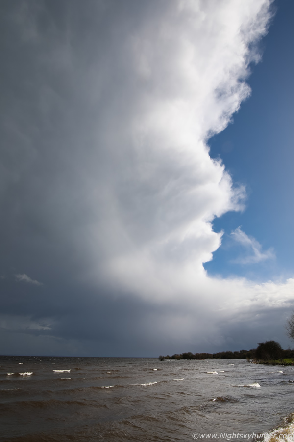
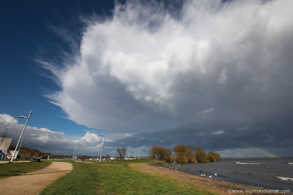
I pulled into Ballyronan Marina just as the first cluster passed the far side of the lough over Co. Antrim, this was the view of the SW side of that cluster where tail end charlie was located, the base was hidden by cloud but check out the anvil, pretty chunky for March and with mammatus on it too.
 |
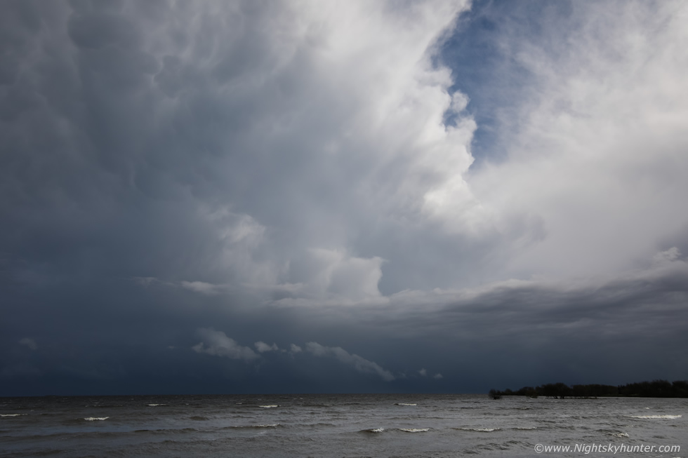
The dynamic range was tough to shoot with one half of the cell in darkness and the rear in bright sunlight, the sun itself was blazing just outside the frame to the upper right, I had to try and keep it out of the field. Super wide angle lens again, moving R to L, check out the structure along the back of the anvil and along the edge of the principle updraught tower partially in view, that's as solid as it gets at this time of year, the anvil shield was blown far downrange out of view to the left. To tell you the truth I was happy enough with this, my first structure of the year.
Then my phone rang, it was chaser Nigel McFarland, he was asking my position and was heading to the lough too, he had just finished work and saw the radar and immediately made tracks in this direction. He informed me that the second cell to the SW was moving up and we should see it soon from the lough so we had another target coming. As I waited on Nigel I made a brew and had a snack to keep the energy levels up then Nigel arrived.
 |
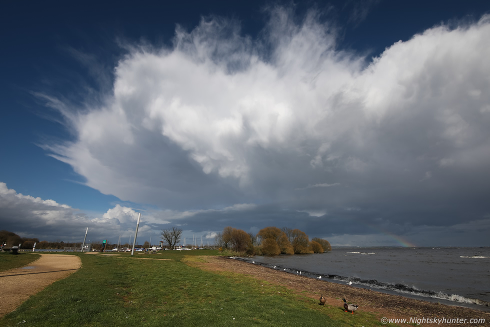
This was the first cell now over the far side of the lough. The cold outflow wind had stopped and the air was calmer and even warm, temps would peak this day between 15c and 17c, the latter in Co. Down. We got the gear set up on the grass bank adjacent to the lough, I had the full frame 5D Mark IV with 15mm wide angle for big structure shots and beside it was the 600D crop sensor with 100-400mm ready incase a funnel or waterspout formed. Nigel had his DSLR tripod mounted with lightning trigger and a second camera ready and waiting. I then got a phone call from John Fagan, he was working in Lurgan but could see the second cell heading our way and said it looked good, we looked to our right and off in the distance was a solitary anvil clearly visible in the sunshine, and it was coming our way.
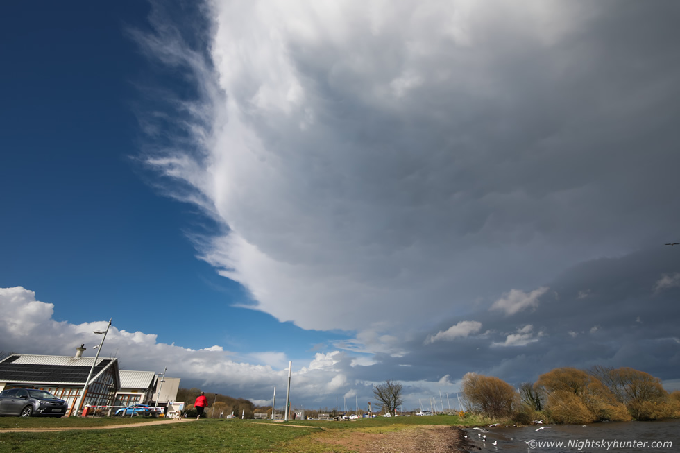 |
Nigel and I were busy chatting and scanning across the lough and lost track of time when suddenly, seemingly out of nowhere, the anvil from storm two was directly overhead. My first reaction was of shock, it only took seconds to gauge that this was an exceptional anvil for the season, the leading edge was sharp and the underside had solid clusters of white mammatus, not the kind which looks weak and indicative of a dying cell but the rarer kind which looks more like upside down convection protruding back down from the anvil due to rapid rising air reaching the equilibrium level. The anvil canopy then passed over our zenith and took up the entire sky sector in this area, even extending over the N portion of the lough, Nigel and I were most impressed.
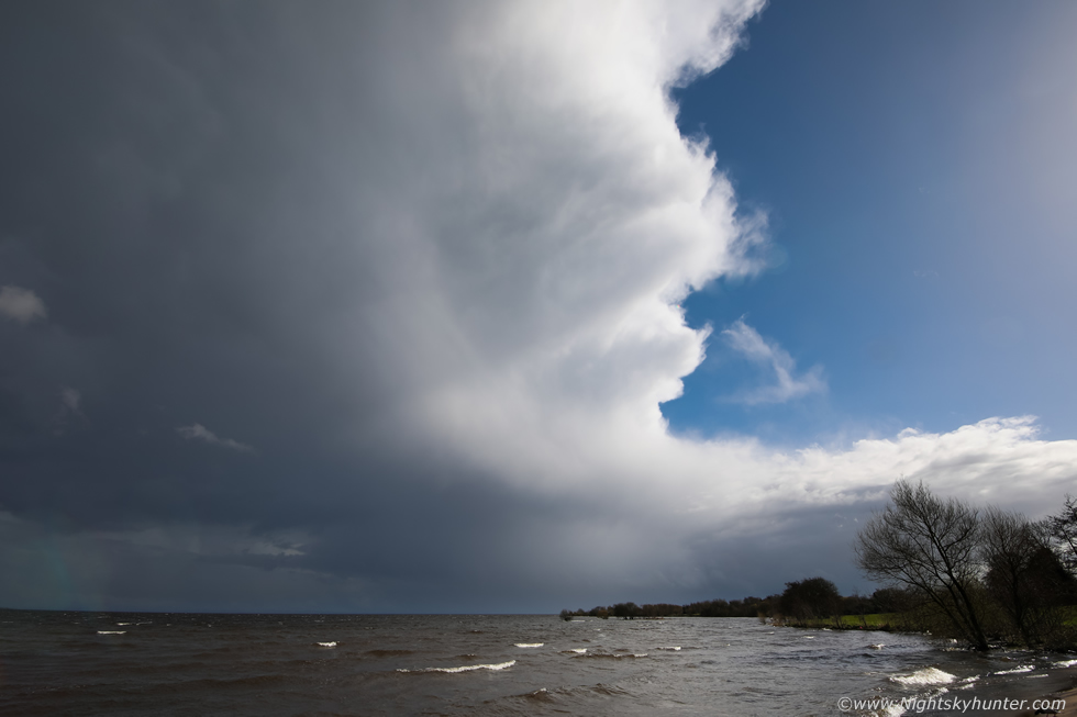 |
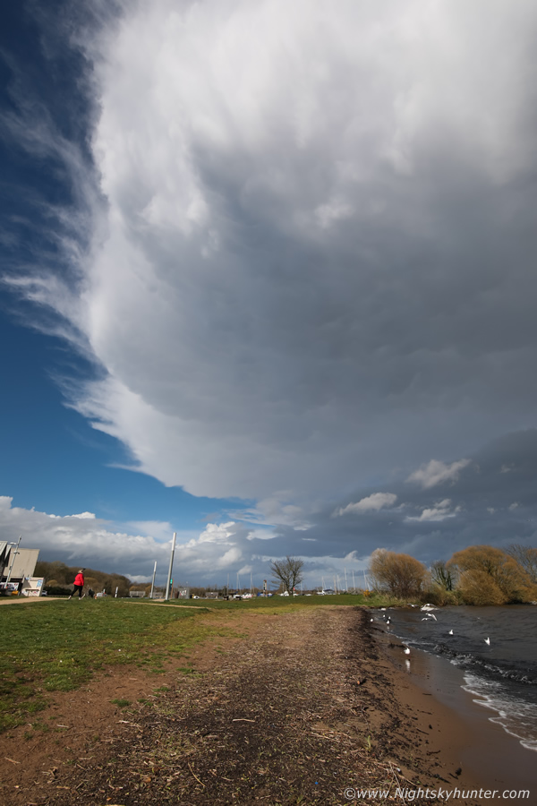
Then imagine turning 180 degrees to your right and this was the back end of the cell now moving into view, I knew in an instant this was not an ordinary cell. This wasn't a cluster or line, it was one long incredibly sheared cell, I quickly came to the conclusion this was likely an LP supercell based entirely on the structure and of course the synoptics. This is 15mm wide angle, this main updraught of the cell was far away to the SE over the far end of the lough and still I couldn't get into the fOV, it extended far above the top of this frame. Moving R to L and away from us, SW to NE.
That's the base of the cell and of a possible brief mesocyclone, don't be fooled by the low contrast look or lack of definition, there was precip falling between us and the base partially obscuring the view, this precip was likely wrapping around the base (see radar below) or was falling from the anvil flank. On the N (left) side of the base was inflow cloud or a beaver tail, this was a persistent featuring visible on the many images I took and was not a transient cloud. Of greater note is the huge vault region between the base and forward flank, a region with little or no rain at all swept clear by the effects of speed and directional shear venting the precip a vast distance away downstream. You can also discern a strongly tilted tower blown downrange to the left where it merged into the big anvil.
Ignore the fuzzy look to the cell, this was likely due to the fact it is only March with limited temperatures and not in the warm season when we would potentially be getting 25c-30c temps in conjunction with stronger CAPE, also I suspect there were issues with the temps aloft which may have hindered it's ability to produce sparks, during the entire period of observation we never heard a rumble of thunder at all, this is not unusual for N. Ireland. However the overall visual appearance combined with the sheared environment indicates an obvious LP storm.
 |
15mm wide angle in portrait orientation and I still can't fit the entire flanking region-anvil interface into the frame. If you have ever used a 15mm wide angle lens on a full frame camera before then you can appreciate just how large this field is, to give a sense of scale the top of the frame is almost overhead.
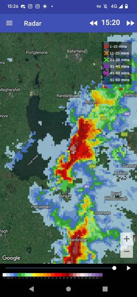 |
Interestingly when you research LP supercells it's surprising to learn that its nearly impossible to identify such a structure on radar. LPs tend to have sheared but weak radar signatures and sometimes very little reflectivity at all, this is why it's important to have storm spotters on the ground to identify such structures. Visually they seldom have obvious RFD and FFD features and on radar they rarely even show a hook echo. However this one was interesting, check out this radar grab taken during the same time as the observation which clearly shows a hook appendage, this also explains the precip between us and the base which at the time was being wrapped around this hook. The radar sequence actually shows that this cell was a left split exactly what TORRO had forecast. Many thanks to Owain Rice for supplying this radar image.
 |
Turning 180 degrees back to the left at the anvil of this same cell. Interestingly, despite the cells being sheared SW to NE the actual anvil was being blown to the W/NW towards us at the same time indicating strong directional shear aloft. Images don't do this scene justice, this anvil was not only massive, it was also very thick and solid, I would say its the most solid anvil I've ever seen in March and actually beats hands down some of the best Summer anvils I've observed in recent years, even on days with prolific thunder, why this thing wasn't sparking was shocking to us at the time, thunder booming across the lough would have been the icing on the cake.
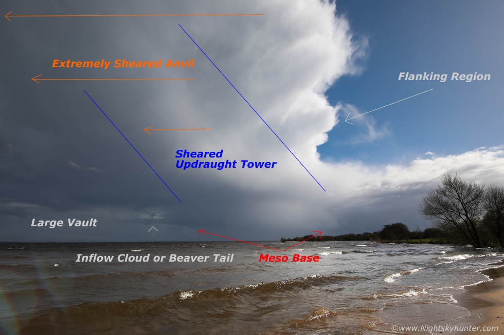 |
Another image of the updraught region annotated with the key structure features of an LP cell
 |
This was huge, remember this is not the back of a cell or orphan anvil, this was attached to that sheared updraught tower far out of frame to the right. The sun was shinning and it felt mild, Duck's were quacking and splashing in the water while this anvil loomed overhead.
 |
Getting further away but such a beautiful sight, even this caliber of anvil on it's own made March for me. The cells in this area and over Antrim looked to be weakening so we packed up the gear. Colleen Webb arrived so we hung around for a while chatting, John Fagan text to say another cell was passing Dungannon and heading for the lough, the precip area at the front looked weak so I decided to make my way back.
 |
Between Ballyronan and Magherafelt I saw beautiful primary and secondary bows but couldn't get pulled over for shots so I kept on driving. Then as I ventured onto the high country roads outside Magherafelt I saw the back end of that cell passing over Antrim, the one which John had text about. The view in the wing mirror was impressive, it looked like a massive updraught had just ballooned upward with a solid plume towering high into the sky, it must have been feeding on the stronger instability and shear in that area, I pulled over for an image.
This doesn't do the visual scene justice at all, this cell was miles away, the precip was affecting traffic in Ballymena, I was using the 50mm lens on full frame. This is looking directly at the flanking region (rear) as the cell was moving directly away from me to the NE, you can imagine the unseen anvil sheared in that direction. Far below the updraught is a white block of cloud, this is not normal cloud or scud, that was the actual updraught base itself which really shows the depth of this cell, that small, compact and somewhat rounded base is another visual sign of an LP structure. I watched for ten minutes hoping for a rope funnel in the sunshine, this was the best looking convection I've ever seen in March.
That night Owain Rice and I discussed the images, radar, and shear profiles extensively and we both agreed that this made for a very good case for an LP supercell. In fact, Owain stated it was rotating in an anticyclonic fashion (clockwise) and reminded him of an LP supercell he witnessed in Maine which looked almost identical to the Lough Neagh LP, it was a very interesting discussion.
Chase vlog, excuse the bad camera angle and rushed job during the talking part as I was literally chasing and in the zone waiting to get to the lough to intercept those cells. I have a clip of the first cell and a pan across the updraught and anvil of the LP. If you factor in these sheared set-ups, the solid anvils, the Shetland Island snow tornado then the midnight damaging tornado over Cork then March really has been an outstanding convective month, I hope this is an omen of an action-packed Summer to come. Thanks very much for reading.
Martin McKenna
